Morgiri is one the unknown hill forts near Lonavla. It is an offbeat trek. One of the most scenic and beautiful forts in the monsoon season. I visited on 22/09/2019 with my Trekking Paltan Group, Pune. Carry the proper Rope with you, it requires on two points.

 Lion Point, Lonavla


 After 20/30 mins of jungle hike you will reach here see to wonderful views. Keep going to the right side.


 Risky patch


 What to See : Nothing much to see on the top. The top is narrow. You can see Tung, Tikona, Koraigad, Kailasgad fort, Lohagad, Visapur, Dukes Nose, Lonavla-Khandala etc.

How to Reach : It is about 90 km from Pune. From Lonavla it is about 30 km.

Pune-Lonavla-INS Shivaji road-Loin point-Ghusalkhamb- there are three roads here- Take LEFT turn which marked as Javan Tungi road in the Google map. (right road goes to Amby valley/Koraigad/Tailbaila/Ghangad/Bhamburde/Tahminighat Centre road goes to Amby valley/Mulashi)-after left turn the base village is about 1km and 10 mins. drive to the base / Parking. There are no proper sign of a village. It is just a settlement of few houses. But the board displayed there "Morgiri fort'.
Left side The Machan-Tree Resort is situated. Straight road goes to Tungi fort/ Essar Aggrotech/ Mahindra resort.

Pune to Morgiri fort base map

Parking : Parking is in open place in the village because it is a private land. Some villagers may ask money for it.

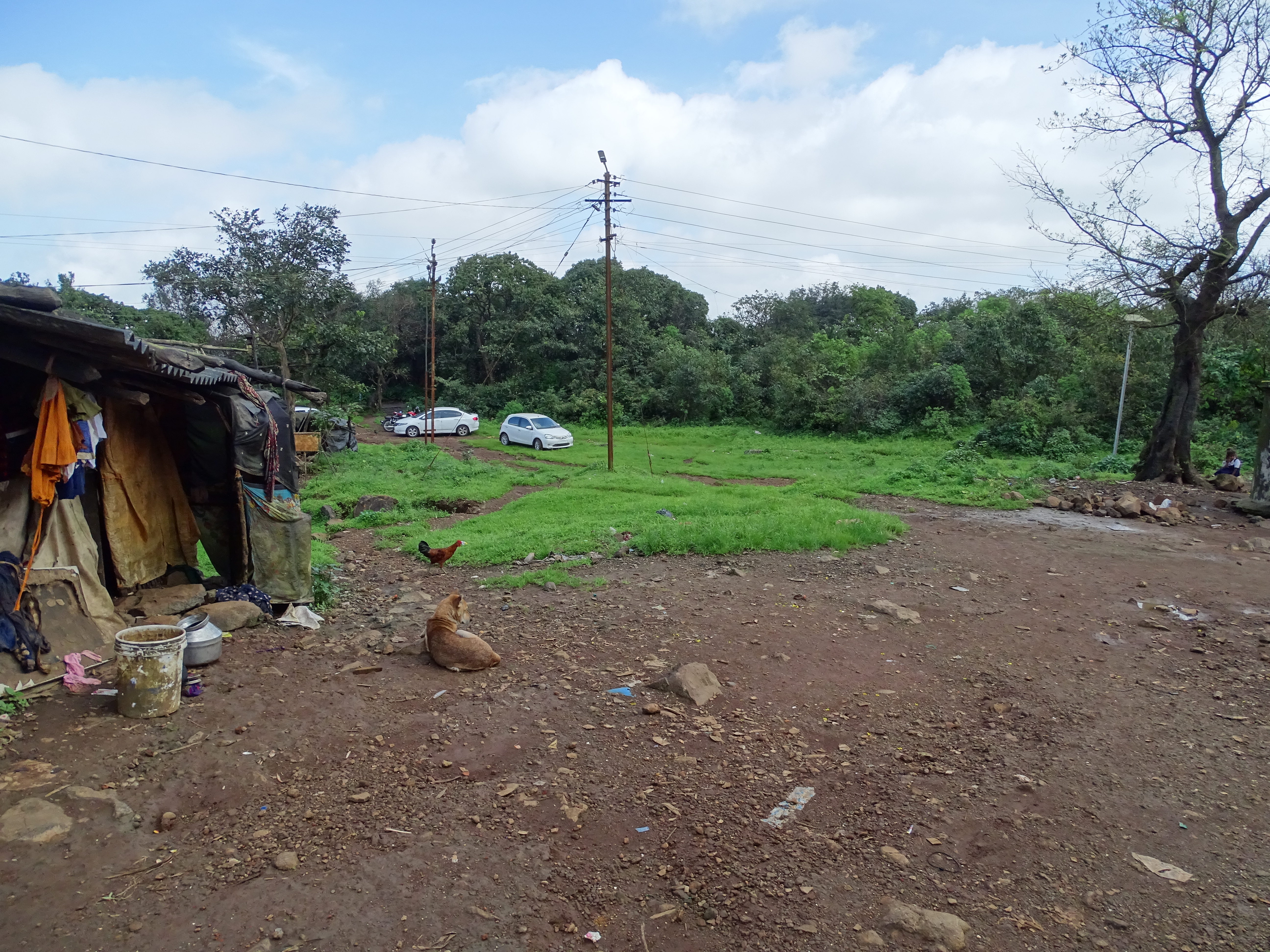
Parking
Food and Stay : No Food and water available on the fort on at the base. Carry all water and food with you. Food and water available at Ghusalkhamb or near lion point. Home stay and home food available at Morve village 3 km ahead of the parking.
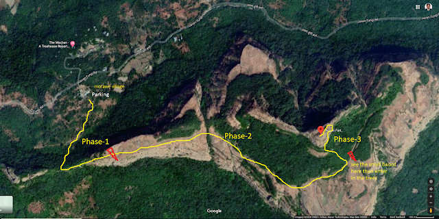
About Trek : It is about 2 hours trek from the Base to Top for normal trekkers. Remember this is offbeat trek so trek route is unclear. So please see the images in this blog. Many wrong diversion are created by lost trekkers or animals. So strictly follow the trail shown in the map here. For better understanding, I have made three phases of the trek.
See this video then plan your trek

Phase 1- First phase is from parking to the plateau. This is about 40 mins. Start from parking. Go the right side in the jungle. Fort hill is on left hand side. Due to many trails you may lost. remember you have to reach in the pass. See you have to reach the Pass (Khind). You can see either sides of the hill. It is through the trees it is a mild ascend. After 15/20 minutes you will reach between two hills i.e. a pass. From here take left ascend of 15/20 minutes. It is a quick and steep ascend. You will reach on plain top land i.e. a plateau.


Phase 2 - This phase is from plain plateau to last ascend start point. It will take 40 mins. It is a plain straight walk. Simply walk on the right edge of the hill. There are many trails going in the left side, don't take it. Straight trail is clear but many misguiding trails taking to the left side of it created by water streams. Just stay on straight course. See the photos below and follow it.

Don't follow misleading trails. Refer this map.


Tung Fort visible from the trail

Phase 3 - Phase 3 is most risky and tricky phase of the trek. It will take 40/50 minutes to reach on the top of the fort. First challenge to find out the exact trail to start. That is why we Trekking Paltan group placed many guiding boards for the proper the route.


Here is the proper route to the top. Find a board.


Once you take a curved turn, the trail may be lost. There is a small but major water stream there. Cross it. then follow the trail. Keep watching left side for proper trail. We made one Stone arrow there. Hope it will be there to help you. If not just see the exact entry point for hike in the map i posted in the blog. But don't fallow the trail straight away, it will take you back to the phase 2 point.


Once You sure about right route, then start it. It is very challenging phase. It start from dense forest and steep hike. Very slippery in rainy days. Keep checking right track. We have tied Saffron ribbon to guide a proper route. Hope those are there.


Here you rich to the most risky part. Some portion are highly risky. Little place to hold and hike. We carried a rope, so crossed that portion with the help of rope. It is small portion of 10/15 steps which is steep and slippery. So be careful because other side deep deep valley only. Go One person at a time.

After risky portion there is ladder there to reach before top. It is unstable ladder. Don't rely blindly on it. If you carry rope, get a help of it here. This is a small ladder of 10/112 steps but very risky.

After the risky points you will be on the top of the Fort. There are no bastion or fortification found on the fort.


Top of the Fort

Trekking Paltan : Hemant Patil, Sandip Jadhav, Nitin Bagle, Parshuram Bhangare, Sachin Shinde, Dr. Suresh Isave, Sandeep Chaudhari, Amol Gore, Pawan Patil, Lalit Bagal, Nitin Kulkarni & Sanjay Vavle behind camera


Return Journey


Lunch at the phase 2 plateau


Pawna Dam and Tung fort from the top

Best Season : Most scenic in Monsoon especially in September.
Precautions :
- Carry Rope.
- Carry all food and water.
- Go with group.
- Take local guide.
- Be sure not to follow misleading trails.
- offbeat trek, so not much trekkers, so go on weekends and with group only.


