Pages

27.10.15

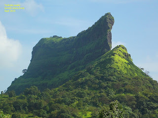
कावळया गड Kavlyagad Fort Trek

कावळया गड  Kavlyagad Fort

The information is based on my latest visit in October 2015
Kavlya/Kawlya fort is recently discovered fort, not much historical information available of it. It is isolated and alone fort where trekkers are rarely found. It was supposed to be a watch tower of Raigad , Rajgad and Kawlya ghat section which connects Bhor and Mahad.

How to Reach : It is about 100 km from Pune. The way is Pune-Bhor-Varandha Ghat-Waghjai Point-Kavlyagad.

By Google Map


It is about 40km from Bhor. In that ghat section is about 35 km of Varandha ghat. Mahad is about 20km from Waghjai point in Varandha ghat. It’s a refreshing scenic journey from Bhor to the fort, left hand side along with the backwater of Neera-Devghar dam and Sahyadri mountain ridge on the right hand side.

The ghat section road is not in good condition, but still it is drivable for two and four wheeler.
You will have to stop near Waghjai point in the Varandha ghat where small restaurants of Kandabhaji, tea, vadapaw, lemon juice etc. Maharashtriyan snacks are available. Ask restaurant owners where to Park Vehicles.

There are no mechanics, petrol pumps and police station in Varandha Ghat section.

Parking : The parking place is available in the ghat at a hair pin turn position from ghat road starts to descends to Konkan-Mahad. There is no protection to vehicle. Park on own risk.

Food n Water : Nothing is available on the fort. Bottled water and snacks are available at Waghjai point in Varandha ghat which is on walk able distance from parking place. Complete meal is available from at the beginning of Varandha Ghat from Bhor side. Good quality veg and non veg restaurants are available over there.

How is Trek : Overall the trek is easy but difficult to keep on right trek. It will take about one hour trek from parking. The initial trek is risky on high descending side of a ridge. So go slowly with support sticks. After slope take right ascending side of trek, you will reach on small plateau which is full of grass. It looks very beautiful with variety of shades of Green. You can see waterfalls in the monsoon season.

Because it is not a popular trek, you will find difficulty to get correct route. So just keep watch on Flag point of the fort and keep forwarding. Don’t be hurry to decide a correct route. Observe keenly. There are jungle kind of plants are there from where you will have to find out routes, because many small diverging routes ( ढोर वाट ) made by animals like cows and goats.

What to See :  There is nothing special to watch on the fort. Fortification is not much remained. Only one Buruz (बुरुज ) i.e. a Flag tower exists on the fort, where you can have your food. There is a jungle on the rest part of the fort. So it is better not to enter in that without experienced trekkers. You can have panoramic view of Shyadri mountains with historically important forts and routes like Raigad, Rajgad, Mohangad, Shivthar ghal, Madheghat etc.

Best time to Visit : From June to December would be the best time to visit.

Precaution: Since it is an offbeat and isolated trek, please search on internet, see blogs and Google earth, ask trekkers and then go with a group on weekends. Avoid to go with Family without a group because the trek route is confusing, non availability of help, water, food and mobile range on fort !

So take care and enjoy Kavlyagad fort trek.


20.10.15

Thoseghar - Chalkewadi

Nearby Tourists Places to Satara

Sajjangad - Thoseghar - Chalkewadi
Pune-Satara-Sajjangad-Thoseghar-Chalkewadi is very refreshing ONE DAY Family tour from Pune. Total distance of a round trip would be 270 km. Road side view is very beautiful and well maintained for driving.

Sajjangad Fort सज्जनगड 
How to Reach : Its about 18 km from Satara city. Its on the way of Thoseghar Waterfall. From Satara city from the base of Ajinkyatara fort, tow roads go, right hand side road goes to Kaas-Bamnoli and right hand side road goes via small tunnel to Sajjangad-Thoseghar-Chlakewadi-Patan
Road condition is very good and beautiful ghats.

Parking : Cars and mini bus can go up to the Praveshdwar (Entry) of the fort. Parking facility available but space is enough for 15-20 vehicles.

Food : Snacks and tea available.


Thoseghar Waterfall ठोसेघर धबधबा 

How to Reach : Thoseghar is about 25 km from Satara city. Road condition is good. Beautiful road with Ghats.

Parking : Ample place parking is available for all types of Vehicle.

Food : One Veg-non-veg restaurant is there at the entrance. You must taste the food provided by local people. Rates are reasonable. Food, cold drink and bottled water is available all the days of week.

What to see : The water part has two parts. End part is called big waterfall, which appears first in the park. The back side of the waterfall is called small waterfall. 
The location is risky up to some extent, hence need to take care of kids.

Best season to visit is the monsoon season. Generally, waterfall remains up to October !


Entrance


Parking Place

Big Waterfall


Small Waterfall


 Chalkewadi Wind Energy Project चाळकेवाड़ी पवनऊर्जा  प्रकल्प  

How to Reach : Its about 26 km from Satara city and about 3/4 km from Thoseghar waterfall. The road takes you on the Chalkewadi plateau. The road leads to Patan-Chiplun in Konkan.

Food and Water: No food n water available on the plateau. No residence on the plateau. So keep your food and water with you ! Or have food at Thoseghar waterfall restaurant and then go to Chalkewadi.

Parking : You can stop any where beside a road. 

What to see : Hundreds of Wind mills which are spread all over plateau. To go closer to windmill is not allowed. But some working personnel you found, you may ask about information about the project.
If you go to the western edges of the plateau, Koyana Dam back waters give you wonderful treat.
Take care of Sun heat. There are no trees on the place, So use cap, goggles to protect form sun light .


24.9.15

Tailbaila तैलबैला


Tailbaila is very popular place among adventure trekkers !!
Its an excellent place for rappelling and rock climbing !!


How To Reach : It is about 100 km from Pune.  There are two ways from Pune.

1.Via Lonavla - Pune - Lonawla-BhushiDam-INS Shivaji-Lion Point- Peth Shahapur- Ambvane village - Amby valley- Bhamburde road-Saltar-take right turn from Saltar- Take a right turn after a small mountain pass to Tailbaila Village-Tailbaila.

Road from Pune to Amby valley about 80km road is very good !! After Amby valley its typical rural single but pakka road bit no problem for car. The distance from Amby valley to Tailbaila is about 15 to 20 km.
On the way Tourists Places - Khandala, Lonaval, Wax musium Lonvla, Bhushi Dam, Lion Point, Amby Vally- Koraigad fort, Pavana dam, Lohgad, Visapur, Tikona, Tung forts 

2.Via Tamhini - Pune - Pirnagut- Paud - Mulashi - Tahmini - after tamhini village leave tahmini ghat Konkna Mangaon road- take a right turn after Nive village to MKCS Ashrram road to Bhambhurde village- on the way you must see Kundlika Valley- go ahead along with Mulshi dam backwaters to Bhamburde village ( 80/90 km from Pune)- you can see Navaraa-Navari ( Bride-Groom) Peaks on the way- Bhamburde village- proceed on Lonavla Road - 3/4 km after Bhamburde village take a left turn before mountain pass for TailBaila village-Tailbaila. 

Pune to Tamhini 70km road is in good condition. From Tamhini to Tailbiala is about 30km road is rural type,pakka, single road. need to drive a car carefully. no problem for bikes and SUVs. 
On the way Tourists Attractions : Mulshi dam, Tamhini waterfalls, Kailasgad fort,Tamhini valley, Kundalika Valley, Ghangad fort, Bhamburde valley


Food and Water : Local villagers may provide home made veg, non-veg food. No mineral water available. First give your order of food, then go to trek. Mr. Roakade Avinash provide tasty and fresh

                                
No hotels and restaurant at village. Before Amby valley at lion point breakfast would be available. Lonavla and Mulashi have hotels for all types of food.

Parking : Local parking place is available to Tailbaila village from where peaks are about 2 km.. walking distance .


What to see : 

1. Tailbaila Peaks- The pair of wall like shape peaks are called Tail-Bail. These looks like natural walls. Its an adventurous spot. Rappelling and rock climbing with the help of expert team and tools is done by tourists teams. You can trek up to half way easily, where a temple and a water tank is there. Regular trekker can rest and take their food on this spot. On this spot you can feel the cool breeze from the gap of two hill walls, tremendous refreshing feeling ! Next half trek is tough and difficult by rappelling, not possible for everyone. You need skill, endurance and guts to climb on 90 degree, straight walls.  


2. Tailbaila Valley - It is one of the deepest and narrowest valley in Maharashtra.             It is about 3/4 km from the village. Bikes can go up to the edge of valley.You can see Ghangad on the opposite side of the valley and Sudhagad to the right side.


3. Mahadev Temple - it is about 3/4 km from village on the edge of Sahyadri. The road is very rough and not used by many. from here you can see Sudhagad, Khopoli-Pen road.


Nearby Petrol Pump : Lonavla and Mulshi
Nearby Mechanics : Lonavla and Mulshi
Nearby Doctor : Lonavla and Mulshi
Stay : No hotels at Tailbaila Village. Home stay is provided by villagers.


IMPORTANT : Generally there are no tourists on weekdays, So take a local guide or anyone form village to show you the right path, other wise there is possibility to get diverted from path especially to the Valley and Mahadev Temple.
Mobile signals are weak or absent. 

Nearby Tourists attraction - Mulashi waterfalls, Tamhini ghat, Tamhini valley, Kundlika Valley, Ghatgad, Khanadala, Lonavla, Bhushi dam, lion point, Amby valley, Koraigad etc.

The information is given on the base of my latest visit in Sept 2015  so it may change.