Railing Plateau


Rayling plateau not known to many people because the area is known and identified as on the famous fort Lingana.
The Lingana fort is famous so the plateau is used to stay or watch the Lingana. But the plateau itself is very beautiful.
The villagers tell that the Railing is named because Raigad and Lingana forts can be seen from this plateau, so its combined the names of both forts and named Railing.
The villagers tell that the Railing is named because Raigad and Lingana forts can be seen from this plateau, so its combined the names of both forts and named Railing.
The plateau is very scenic in the monsoon and its full of tiny flowers and grass in winter. This a perfect offbeat location for camping and overnight stay.
How to Reach :
Its about 90 km from Pune. Its 3 hrs journey from Pune by private vehicle.
You have reach to Velhe
i) Pune-Khandkwasla_Khanapur-Pabe Ghat-Velhe,(46km)
or
ii) Pune-Banglore highway-Shindewadi-Toll plaza-right turn from Nasrapur-Velhe (56km)
Velhe-Bhatti-Kelad Khind- (12km) Take right turn immediately after Khind (pass) to Singapur Mohari villahe raod- Next road is on the top of the ridge of almost 10 km. The raod is rough and stony. Not suitable for city cars. Drive carefully because decends on both side of the raod. Its loneley road. No Shops no stores.
After hard ride of 30 mins you will reach to the Mohari village. left turning road goes to Singapur village, Here the slope is very steep, so park your four wheeler here. Two wheelers or samll cars may taken ahead to the Mohari Village.
But you are advised to park vehicle downside.
Last petrol pump and stores are at Velhe only.


Food and Stay :
Mohari and Singapur both are small villages. No restaurants and shops are available here. So nothing will be available there. Some villagers may cook food for small groups on request.
Tiffins are suggested. It will take 6/7 hours to return.
Home stay may provided in both villages or u may camp here.
Mobile range not found.

Singapur village

Mohari Village

About Trek :
The trek is simple and easy. But the route is confusing. There is every possibility to get lost in the deep n dark jungle. There are many routes you will find due to animals and water channels. It is critical to select the right way. Wait and use directional sense to find expected route as per your plan. The routes are indicated A,B,C,D in the map below.
Route A :
Its will take 2:30 hrs from right side route. Its extreme right side route. The longest route to reach Railing plateau. If you want more trek then follow this route. It will show you wonderful view of the edges of Sahyadri.


Route B:
This route goes on the top of the hill and you can trek by watching better view of the surrounding. It is best Photographic route but lonely at the same time. It is a trek of approx 2 hrs.


Route C :
It is a shortest route. Take left to reach the plateau from the juctions of route. It will take approx.1:30 hrs to reach the plateau. You may confuse with the trail of Boratyachi Naal which goes to Lingana fort base. So be careful, if you lost you will reach at the base and not on the Railing Plateau.


 Route D :
Its will take 2:30 hrs from right side route. Its extreme right side route. The longest route to reach Railing plateau. If you want more trek then follow this route. It will show you wonderful view of the edges of Sahyadri.


This route goes on the top of the hill and you can trek by watching better view of the surrounding. It is best Photographic route but lonely at the same time. It is a trek of approx 2 hrs.


It is a shortest route. Take left to reach the plateau from the juctions of route. It will take approx.1:30 hrs to reach the plateau. You may confuse with the trail of Boratyachi Naal which goes to Lingana fort base. So be careful, if you lost you will reach at the base and not on the Railing Plateau.


The route takes you to the base of Lingan fort through Boratyachi naal (बोराट्याची नाळ ) which also start from the same Mohari village. As soon as you enter in valley with stony path, you should understand that you have entered in Boratyachi Naal.
There are no marking for different routes. Its a dark jungle from where these different routes separated So better to take guide( वाटाड्या )from village. Boys from the Mohari village happily serves this task without much expectations.

There are no marking for different routes. Its a dark jungle from where these different routes separated So better to take guide( वाटाड्या )from village. Boys from the Mohari village happily serves this task without much expectations.

In case of confusion keep left for Railing plateau. Its a shortest way to reach the Railing plateau. If you lost, Don't be panic you will reach from the longest route to the same plateau. The plateau is not connected with any ridge, so you can reach at the cliff from where you can turn by using common sense.


Some trekkers plan to take round trip. They goes from right side and come back from left side route. Its a hill top plateau, so Don't worry if you lost. But you to change time plan.

What to See:
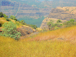
More than destination, the route itself is scenic. There are many streams and waterfalls around from July to November. Different kind of tiny flowers and grass make this route more beautiful. You can drink the sweet water from streams if your guide suggests.
Grass up to 3 feet high will make your photos more attractive.
The plateau is like a table top vast land with grass cover and rock. It is the perfect place for the Camping.
There is small stream at the east side of the plateau which runs upto month of November generally.
From the Plateau you can see huge thrilling Lingana fort very near to you and the glorious Raigad in the backgourd.
The Lingana trek and rappelling points are clearly visible. The Cave which was used as a Jail also visible from Plateau.
The Takamak tok, Jagdishwar Temple, the Samadhi of Shivaji Maharaj, Darugola Kothaar of Raigad can be easily seen with naked eyes. The view of Raigad would be more clear in the morning due to sunlight angle.
The Konkandiva fort to the extreme right side (North-West) also visible clearly.
Varandha ghat, Kavlya fort, Madheghat, Nanemachi waterfall and Shevate waterfall region is visible to the East-South direction.(Left-Front side)
Torna fort is situated to the East direction and Budhala Maachi of Torna fort is claerly visible.
Kal river bank can be seen from the plateau which separates the Sahyadri cliffs from Konkan region.


Trek-Safety :
- Remember it is off beat and lonely destination.
- Visit only on Sundays.
- Visit with group.
- Prefer experienced and professional groups.
- Road from Kelad khind to Mohari is very rough and stony. Drive carefully.
- No petrol pump, stores and shops after Velhe.
- Mobile coverage is weak, don't rely on it.
- Take village guide with you.
- Confirm food and stay facility.
- Carry sufficient water and dry snacks.
- take every step carefully in forest part of the trek.
- Dont be over confident about routes.
Perfect!
ReplyDeleteKhup chhan :-)
ReplyDeleteThanks for very informative writeup. If I am planning to take my city car, how far can I go past Velhe before the road gets bad and I have to park and start walking?
ReplyDeleteroad is not good for cars after 10 km from velhe when you take right turn after small pass, to singapur mohari road. need some rough vehicle there. parking is at Mohari village.
ReplyDeletethis website Took me time to read all the comments, but I really enjoyed the article. It proved to be Very helpful to me and I am sure to all the commenters here! It’s always nice when you can not only be informed, but also entertained!
ReplyDeleteNice post.Thanks for sharing
ReplyDeletecamping in khopoli
Pawna Campers is the ideal location if you're searching for a memorable camping trip close to Pune!
ReplyDeletetent camping near pune
Very much thanks 🙏🙏
ReplyDeleteVery Good information given. Thanks.
ReplyDelete