Pages

Showing posts with label pune treks. Show all posts

1.8.15

Madheghat Waterfall

Madheghat is very refreshing trail point near Pune. It is a simple jungle trail full of forest and small water streams. The waterfalls are very enchanting in rainy season. Madhe Ghat is historical route. Shivaji Maharaj's great worrier Tanaji Malusare died while fighting on Kondana (Sinhagad) fort. His dead body was carried via this route called "Madhe Ghat" to his native village in Konkan. Madhe means dead body in Marathi.
Strongly recommended to go on Weekend or National Holidays, otherwise you feel feary silence. No one is there. 


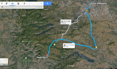
How to Reach - Pune to Madheghat is about 75 km. Entire journey is very very beautiful. There are two ways.


1. Pune-Nasarapur-Velhe-Bhatti-Kelad-Madheghat
2. Pune-Khanapur-Pabe Ghat-Velhe-Bhatti-Kelad-Madheghat
Apart from these two ways there is another way from Bhor and Shivthar Ghal to Madheghat trek from Konkan. But above mentioned two routes are convenient and less risky.
Avoid to go by public transport because of less frequency. Prefer Car, SUV or Bike !
For Velhe to Madheghat there are two ways immediate after Velhe. Old road from the Dam side is better which is very close to Gunjavani backwaters. The new road which is top side of the backwater which is muddy and rocky is under construction. 


Parking - Road is quite good for cars n two wheeler. Parking Place is there one kilometer before the waterfall. Bike and SUV can go on the spot smoothly. After parking simple walk of one kilometer is there to reach the waterfall.

What to See - When u reach on the spot a small plateau is there. On the plateau small streams going to waterfall are wonderful. tourists of all ages can enjoy watering here by taking precaution. All streams joins together on the edge of plateau from where a fascinating waterfall begins. Its wonderful experience to watch a waterfall from its top. Water goes down with high speed and sometimes comes revers back on the top like a fountain due to velocity of wind !! Refreshing experience to get wet on the top of the waterfall. 
There is a risky trek to which takes you at the base of waterfall. Its very risky and slippery. Avoid it. But some tourists go there to feel adventure n thrill. Just remember someone is waiting for you at home.
There is another waterfall on about 800 meters from first one which is bigger and more beautiful. It is a must watch thing. Less people goes there. 


From Madheghat you can see the places in clear air are Varandha ghat, Shivtharghal,                   Konkan, Raigad, Lingana, Mahad, Gunjavni Dam etc.

Best Season - Monsoon to December is the Best season. 

Food - Home food is available at nearby village like Kelad केळद . You can contact to Mr. Ankush Shinde - 96734433773 for home stay and food . Small temporary tea stalls are there on weekends for tea, bhaji and vadapaw etc. Better to take tiffin from Home. Or Can take from Velhe which is Taluka place where you will get food n water even rooms. If carry food its magical to have food on the plateau. 


Tourists Places Nearby - Sinhgad fort, Khadkawasla dam, Panshet, Varsgaon dam, LAVASA city, Bhor, Bhatgar dam, Torna Fort, Rajgad Fort, Lingana, Raigad, Varandha ghat, Shivthargal etc.

Nearest Petrol Pump and Police station - Velhe which is about 18 km from the spot.


Google map

1.7.15

Rajmachi Fort

Rajmachi fort is about 20 km from Khandala- Lonvla.
Acually Rajmachi fort is the pair of two forts i.e. Shrivardhan and Manoranjan !

How to Reach- There are two ways to reach the Rajmachi forts
1. Lonaval- from bus stand to Tungarli Udhewadi is base village 
2. Khnadala - Kunegaon- Delas adventure- Tungarli dam- Rajmachi
3. Karjat-Kondhiwane-Rajmachi

(https://www.google.co.in/maps/dir/Udhewadi,+Maharashtra/Khandala,+Lonavala,+Maharashtra/@18.8203748,73.3899898,15z/data=!4m13!4m12!1m5!1m1!1s0x3be7fe3e8367cdab:0x86720ebe61392bc!2m2!1d73.3942625!2d18.8260071!1m5!1m1!1s0x3be8012af5c2dcbd:0x4e9a732d604a9bd9!2m2!1d73.372!2d18.758)

I have went by Lonavla city. Trail from both side is beautiful.
The road is rough and dusty. Very difficult for car. even no easy on bike. lots of stones and layers of wet or dry soil. Very difficult to manage to control on vehicle. Road will test your driving skills.
better to walk on trail.
Prefer to go via Khandala instead of Lonavala even on bike.

Udhewadi is the base village where water n snack food available on order. 
It is very good Camp site !
Stay facility is available !

Both forts can be done in one day visit ! 
Both requires 30/40 mins each for beginners!

To reach the base is difficult but actual trekking is very easy. It can be done with Family !

From Top you can see Khadala Ghat, Waterfalls, Shirota dam backwater and Karajat area !


Road to Rajmachi fort

Rough and tough road to Rajmachi fort


Manoranjan Fort (Rajmachi)Udhewadi from shrivardhan fort

26.6.15

Kundlika Valley

Kundlika Valley is very beautiful and mind blowing place. The Valley is created by erosion of the river Kundalika !

Location - Near Tahmini Ghat.
Distance from Pune - 60-70 km approx.

How to Reach -
1. Pune - Mulshi-Tahmini-Nive- right turn to Bhamburde - next to MCKS        Ashram.
2. Pune-Lonawla-Bhamburde-to MCKS ashram raod, near Pimpri Dam 

 Follow the link for Google Map :
https://www.google.co.in/maps/place/Kundalika+Valley/@18.5100178,73.4162313,1588m/data=!3m1!1e3!4m15!1m12!4m11!1m3!2m2!1d73.4099442!2d18.4588868!1m6!1m2!1s0x3be81f0cd81e4719:0xaa4fbdb366cfdba3!2sKundalika+Valley,+Patnus,+Maharashtra+412108!2m2!1d73.409258!2d18.468005!3m1!1s0x0000000000000000:0xaa4fbdb366cfdba3!6m1!1e1 )

Best season - Anytime, but best in Monsoon.

Food n Water - Nothing available.

Nearby Hotels at Mulshi-Tahmini ghat, and Lonawla

The place is quiet and isolated. So go in groups.

Edges of the Valley are very risky, so take care of hyper personalities.

Great photographic and scenic location.


Konkandiva Valley Trek

Konkandiva Valley Trek

We went to Konknadiva fort in Jan 2015.

It is about 100 km from Pune.
Pune-Panshetdam backwaters to Ghol village.
Garjaiwadi is base village 6-8 km to Ghol village.

Ghol to Gajarewadi road is very rough and not suitable to regular cars. bike or SUV will do only.


From Gajrewadi to Konkandiva fort one hour trail from forest. must take someone from village as a guide. Mr. Polekar helped us by sending his son with us. His mob no is 9423 447 438 / 827 557 1137
No food or snacks facility at the base village. Please carry water and food.

Konkandiva trek is very difficult and risky. It has steep and sleepery climb.angle is more than 45 degree. take rope with you. children, ladies and bigginers need to take special precaution. Last phase is most risky.

will take two hrs for whole trek. Actual Climbing will take one hour.

But on the top View is fantastic. you will forget your fatigue. worth to take risk.
Raigad and Edges of Sahyadri is so Madly Beautiful...!!
Konkandiva built as a watch tower of capital of  Maratha empire.. Raigad.


By Google Map