Kothaligad fort ( Peth fort)
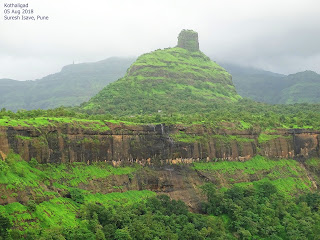
Kothaligad is one the most scenic popular fort. It is also known as fort of Peth named after base village Peth. Its very photogenic because of its 'Bell-Shaped' look.
 How to Reach : Its about 140km from Pune.

Pune-Lonavla-Khandala-Khopoli- exit from right turn to Karjat-Posari-Kadaw-Takawe-Kothimbe-Jambhawali-Kothaligad base
Public transport is to the base village Jambhvali is available from Karjat, Kadawe and Panvel.
Food : Food and water available at Jambhawali & Peth. There are veg and non veg restaurants are there at Jambhawali. You can order food and can have it when you back from trek.No food on the top of the fort.
Parking : Non paved parking is there at Jambhawali for buses, cars and bikes beside
restaurants, which may be chargeable.
Stay : Home stay available at Jambhwlai and Peth village.
About The Trek :
The trek starts from Jambhwali village after parking. It will take almot 2.30 hrs to reach on the top of the fort. Total time for trek to return parking may need 7/8 hrs for normal groups.
Follow the trek route and go to left in case of divergent. After 10 mins there is a forest check post there. They charged Rs.50 per head from us.Then ascending starts with snake turns.


After 40 mins you will reach on the top of plateau. The view is spectacular and your steps will slow down to watch it. The beauty of Kothaligad and its bell shape is visible from this plateau. In monsoon, there are many waterfalls parallel to the edges and makes the fort more scenic and photogenic.

 There is a small temporary restaurant is


found here on weekends in monsoon. Here you can spend 20 mins easily for taking photos because its most photogenic point on the route with backdrop of the fort.
 After chilling out here proceed to Peth village which will be there after 20 mins.


There is Kaccha road upto here from Jambhwali village. Local uses this road for bikes and bull-kart. Peth village is at the foothill of the fort. There are small restaurants and homestays are here too. Guides can be taken from the village. Villagers are friendly.
Then real fort ascend starts from Peth village. It is very steep and vertical. Since its a popular fort,you will come across many groups and foreigners too during trek. Because the route is narrow go with cooperating each other. Help girls, kids, senior citizens and foreigners.
There are almost 80 degree slanted steps to the ceiling to go on the top. Its a windy and narrow way, so go slowly and carefully. Its most risky section of the fort. In normal conditions you will need 5/10 minutes to cross this section.
Water bottles and Limbu sarabat stalls are there on the whole trek.


On the Fort : Finally, after 2 hrs and 30 mins,you will be on the narrow top of the fort. You can see lots of waterfalls around the region including Bhimashakar region. The wind energy project adds spectacular view.


There is a small temparory stall here selling water and Limbu sarabat here on weekends.
Keep calm and click photographs, as many as you can.
Its a plain top with no cover. Groups can eat there tiffin here.
Nearby Places : Khanadal, Lonvla, Zenith waterfall, Mathran, Bhimashankar, Prabalgad, Karnala fort etc.
( Recently i visited with 11 members with my trekking Paltan group Pune and carried out cleanliness campaign Friendship Day 05/082018)


