Pages

26.10.20

Chandangad fort Trek Aug_2019

Chandangad Fort trek


Chandan-Vandhan forts are popularly referred together like Tung-Tikona, Lohgad-Visapur etc. Actually these are two separate forts situated on the same ridge hence connected. Both forts trek is possible in one day for experienced trekkers with great stamina.

Chandangad trek is a small trek of little more than one hour. You can return to the parking in 4/5 hours. It is easy for all the ages. Since it is not so popular please visit on Sundays. Popular time to visit is monsoon. Because there are religious places on the fort please respect the faith of the people and behave accordingly. 

How to Reach from Pune: The route on Google map but the map also confused between Chandangad and Vandangad. So better you search for Banavadi village near Chandangad. 

It is about 100 km. from away from Pune. 25 km. from Satara city in Maharashtra. 

Route-1(95km) - These is recommended route. Pune-Bangalore highway-Shirwal-Bhuinj-take left turn-leave the NH48-Proceed to Karkhana road-Bhivadi-Kalagwadi-Belwandi- go further - Kholvadi- you can see wind mills on the hills- stop near Lord Ganesh Temple which is situated in the small pass (Khind)- or go to Banvadi-Praking

Route-2(120 km) -Pune-Saswad-Jejuri-Walhe-Nira-Lonand-Wathar-Banavadi (base Village)-Parking 

Google Map

Parking :
Parking place is free. You can park it at the base villages or near Lord Ganesh Mandir.
                      
Food and Stay :
There is no food facility available on the fort. There are many small villages nearby where homemade food and restaurants are available.
Two routes to trek. we started from Lord Ganesh temple

About Trek:
There is huge confusion about the identification of the forts even in local people. The confusion is which fort is Chandan and which Vandan. So your thoughts clear on which fort you want to trek and ask accordingly to local villagers then park vehicles accordingly.

The trek is simpler compare to Chandan fort trek.  It any take 40/50 mins to reach on the top. There is proper steps made by forest dept. Even some landscaping and beautification has been done too for initial phase. We parked vehicle near Lord Ganesh temple and started trek.


When ascending you can continuously see Vandangad on left side of the trail. After 15-20 minutes, you will reach to a small temple on the route, take right turn, follow the trail. 
Once taking right turn from this temple plain trail is there, taking you the opposite side of the fort.

Then you will meet a trail coming from the Banavadi village. 

This leads to other trek route coming from the Banavadi village. Then take left with steps and ascend. From here broken steps are found, follow it. 


Wind mills opposite hill on the fort


After a trek on 40/50 minutes you will reach a fallen entry of the fort (Darwaja) 

Then in 5 minutes you will reach the Chandaneshwar Mahadev mandir. Someone form local people say, guess the name of the fort nominated on the name of the Lord 'Chandaneshwar'. There is mighty banyan tree situated near the temple. 

Lord Chandaneshwar Mahadev Temple

Huge Banyan tree
Behind the temple the stone structure is built. Its huge but looks unstable which appears to main entrance of the fort. From here vast plateau like area starts. The shape is triangular. You can say you reached on the fort. It takes almost 70/80 minutes to reach. To explore the fort, one hour is enough.
Walking straight there is the 'Darga' (Muslim religious place) situated. 
Take right side trail which will take you to one bastion. Before that some small water bodies and structures. There are many wide mills on the front hills. 


Just go along with the edges of the fort. On the other side you can see Satara highway side. Walking straight will take you from where Vandangad is visible. It is connected with a small pass. both forts are situated on the same ridge, so they are cohesive.  Vairtagad fort also visible on the other side of the highway.
Vairatgad fort from Chandangad 
way to Vandangad view side
vast plateau of the fort
Vandangad view 
From this point go the the left side and you will reach to the Dargaa again. Whole round will take almost an hour. There are no Food and water available on the fort. 

Chandangad view from Banavadi Village
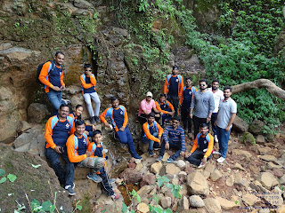
We the members of Trekking Paltan group carried out cleanliness campaign even in rain. We collect  plastic waste thrown by visitors on the fort. 


 We celebrated out friendship day 2019 on Chandangad fort by doing cleanliness. 
We the Trekking Paltan Pune group members from left Sainath Jagdale, Shrirang Gorse, Sandeep Chaudhary, Ankush Dupatne and Myself Dr. Suresh Isave participated. 

23.10.20

Vajrai Waterfall July_2019

Vajraai Waterfall

AboutIt is claimed one of tallest waterfall in India and the tallest in Maharashtra. It runs only in monsoon season. I visited on 21/07/2019 with my Trekking Paltan Group, Pune


How to Reach from Pune : It is about 140 km from Pune and 35km from Satara. There are two ways to reach waterfall after Kaas plateau.

1.Waterfall view : It is easy and gives full view of the waterfall you can see all phases of the waterfall. Good photogenic view from here.

Pune>> Satara city >> Kaas-Bamnoli road >> Kaas plateau >> Kaas lake >> Take left turn after the kaas lake dam wall, there is an archa opposite Kasaidevi temple >> it is a small and rough road through a small village >> after 5/10 mintues muddy drive you will reach to the parking. The parking is paid.

2. Base of the Waterfall : If want to go the base of the waterfall means under the water then follow the route

Pune>> Satara city >> Kaas-Bamnoli road >> Kaas plateau >> Kaas lake >> Take left turn after the kaas lake dam wall, there is an archa opposite Kasaidevi temple >> Take left after the village >> road is narrow and rough, drive carefully >> reach to Bhambavali village >> Park vehicle near Vaghaji mata Temple

Parking: Parking is paid and supervised and ample to park bus, car and bike.

Food and Stay: Food and home stay available at Bhambavli village. If you looking for professional stay then prefer to stay at Satara, Kaas or Bamnoli.

There are no sure facility of food at the base village. There some small restaurants and homemade food suppliers, but you need to confirm first by calling them. Sai Tours and Travel - 081085 29619 

Best stay and food is available at Bamnoli contact Hotel Bhairvnath, Mr. Dhanaji Sapkal, Sarpanch 9421216232. He has boating and camping facility too. He makes arrangements to Vasota fort trekking and boating. You can see details on Google map. 

You can see the waterfall and go for the lunch to Bamnoli which is 30 mins drive from the waterfall. 

Mobile Network: Network is moderate.

About the trek:

Waterfall Top view – After parking vehicle Just walk for 15-20 mins then you will reach on top, the waterfall view not really giving idea of the height from this point but view is very beautiful.

Waterfall Front view – If you want to see waterfall view then its simple walk of 15-20 minutes. Follow the trail which very clear, just follow it. It takes you view point. It is on the edge. So be careful while photography. The view of three phases of the waterfall is clearly visible form here. You will get a poster shot view of the waterfall. This is best point to see the waterfall with all its glory.

Waterfall base view – You need atleast an hour trail from Bhambavli village to reach the base of the waterfall. The trail is very risky and slippery in the monsoon. Better not go with children and senior citizens. Take a local guide from the village. They ask nominal charges like Rs 300/500. It is must for safety because the way is on the side way of the fast running water coming from the waterfall.  When you reach just take all the precautions before going in the water. Better not to enter in the water stream. There are many whirlpools are found. Here you can see the mighty waterfall. Of course you not able to see all the phases of the waterfall but you feel it with the force of the water.

Precautions:
§  Land is slippery in rainy days.
§  Avoid to go in the water.
§  Better to see the waterfall front view.
§  Waterfall generally appears in the monsoon period that is June to September.
§  Avoid to go during heavy rainy days because lots of mud and land becomes slippery, on the other hand due to the moist and fog, you can’t see the view of the waterfall.
Nearby Places - Kaas plateau , Kaas lake, Bamnoli lake, Vasota fort, Tapola, Mahabaleshwar